Jatbula Trail
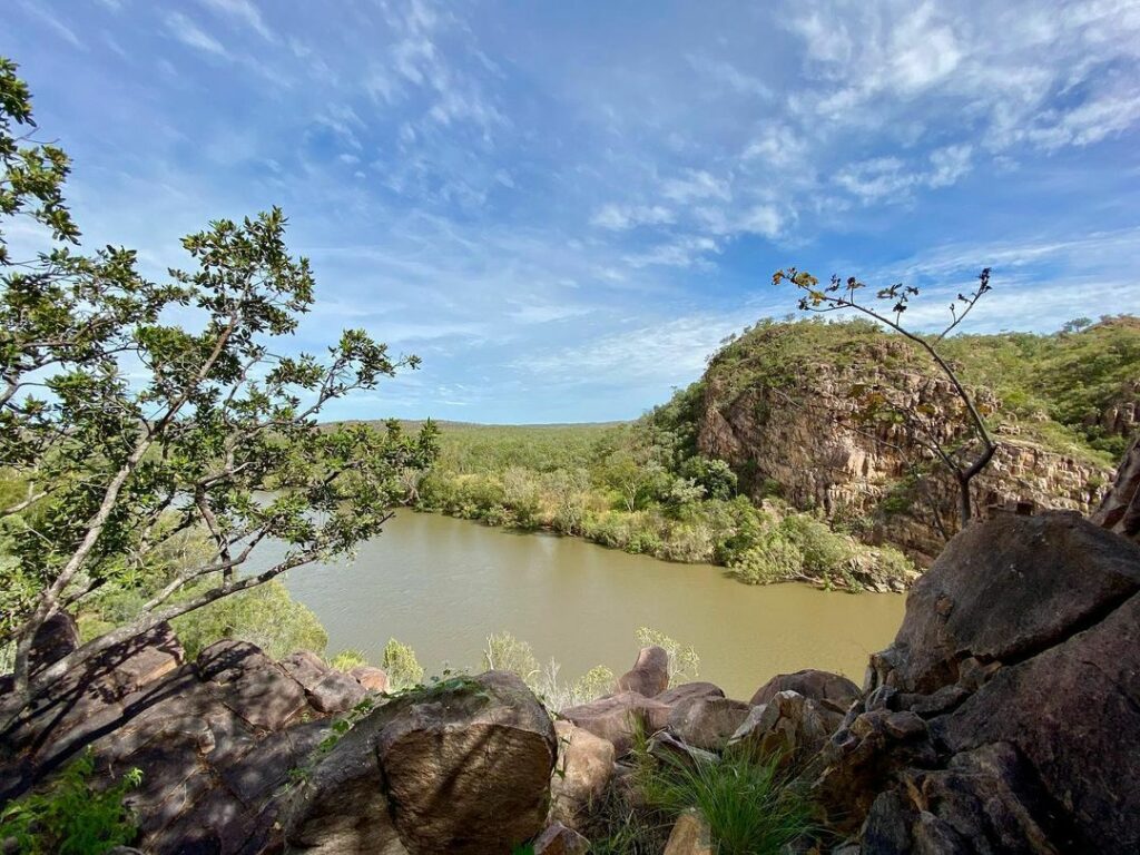
Named after the Jawoyn Traditional Owner, Peter Jatbula, the Jatbula Trail is a 62km (38.5 miles) one-way hike located in Nitmiluk National Park in Northern Territory. The Jatbula Trail begins at Nitmiluk (Katherine) Gorge and ends at Leliyn (Edith Falls), traversing the western edge of the Arnhem Land escarpment. Hikers on the Jatbula Trail can follow in the footsteps of the Jawoyn people, who have inhabited this land for generations.
Planning a hiking trip on the Jatbula Trail? This guide includes how to get there, detailed steps required for your Jatbula Trail booking, a handy Jatbula Trail map, and updated information on Jatbula Trail costs.
The Jatbula Trail Hike - A Nitmiluk National Park Guide
Jatbula Trail Map + How to Get There
Where is Jatbula Trail? Jatbula Trail is located near Katherine in the Northern Territory. The starting point (Nitmiluk Gorge) of Jatbula Trail is 27km away from Katherine. The end of the trail at Leliyn is approximately 63km away from Katherine.
How to Reach Jatbula Trail: If you’re traveling from Darwin to Katherine, your options are to take a 55-minute flight from Darwin International Airport to Katherine Airport or to drive 317km (4 hours) to Katherine. If you want to drive, take National Highway 1 in Holtze from the A15. Then, follow National Highway 1 to O’shea Terrace in Katherine.
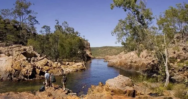
Jatbula Trail Ferry: To get to the trail, you can be picked up from Katherine to Nitmiluk Gorge, which is 27km away. From Nitmiluk Gorge, you need to take a ferry from Nitmiluk Gorge to the start of the trail at 17 Mile Creek. The ferry costs $23 AUD per person and departs twice a day–once at 7 A.M. and once at 9 A.M. Passengers must be at the boat ramp 15 minutes prior with permits ready in hand. Book your ferry with Nitmiluk Tours.
Transfers to Visitor Centre or Katherine: Once you finish the 62km hike and end at Leliyn, you are eligible to be transferred to the Nitmiluk Visitor Centre or Katherine. Leliyn to Katherine is a 63km (45-minute) drive, and Leliyn to the Nitmiluk Visitor Centre is a 90km (1 hour) drive. Gecko Canoeing and Trekking offers transfers.
By car: Cars can be parked at public parking lots on both ends of the trail. However, you must tell Leliyn kiosk or Nitmiluk Gorge’s desk the details of your car, your name, and your return date.
Jatbula Trail Booking
Jatbula Trail Cost: Check out the updated information on Jatbula Trail costs here.
How to Book: Before you use the Northern Territory’s official government website to book your Jatbula Trail trip, you need an account on the booking system with a valid email address, as well as a credit card to pay for the trip with. See our complete guide on how to book and tips for ensuring you get one of the coveted bookings.
Then use the Northern Territory Parks Booking System to book your multi-day walking trail reservation. Choose the Jatbulta walk and include your start date, number of nights, and number of people. Next, choose a campground. Finally, reserve your trip and complete the final details, pay, and you’re set to go trek the Jatbula Trail!
If you’d prefer to experience the Jatbula Trail with expert support, booking a guided tour is a great alternative to trekking independently. Guided walks take the pressure off planning logistics like food drops, river crossings, safety considerations and campsite organisation, while also adding depth to the experience through local knowledge of the landscape, wildlife and cultural significance of Nitmiluk National Park. For many walkers, it’s the easiest way to fully immerse yourself in the trail while focusing purely on the walking, swimming and scenery.
Gecko Canoeing and Trekking offers several guided options. Their guided Jatbula Trail treks include experienced guides, meals, camping equipment and park permits, making them ideal for those wanting a well-supported multi-day hike. You can also opt for a Jatbula Trail and Katherine Gorge canoe combination, which pairs the iconic walk with a peaceful paddle through Nitmiluk Gorge — a standout way to see the park from both land and water.
Jatbula Trail Itinerary
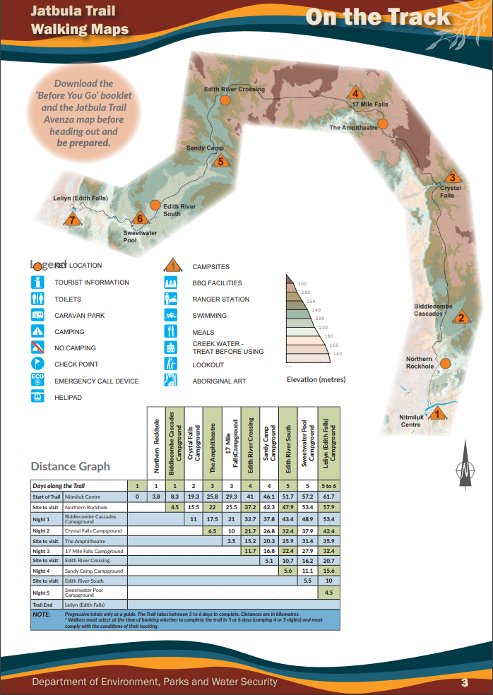
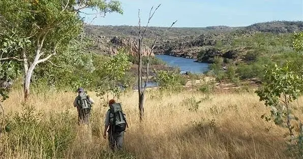
The Jatbula Trail is commonly completed over the course of 5-6 days. Each night is spent at a campsite you book in the trail’s booking system, and each campsite is located near a beautiful spring, waterfall, or cascade.
Day | Trail Length |
1 | Nitmiluk to Biddlecombe Cascades – 8.3km |
2 | Biddlecombe to Crystal Falls – 11km |
3 | Crystal Falls to 17 Mile Falls – 10km |
4 | 17 Mile Falls to Sandy Camp – 16.8km |
5 | Sandy Camp to Sweetwater Pool – 11.1km Direct to Leliyn – 15.6km |
6 | Sweetwater to Leliyn – 4.5km |
Follow Us
Get your daily fix of Northern Territory beauty by following us on Instagram

Join our Newsletter List
Be the first to get travel hints and local recommendations.
What to Pack For The Jatbula Hike
Packing well for the Jatbula Trail is essential for staying comfortable, safe and self-sufficient over multiple days. Conditions can be hot and humid, with river crossings and overnight camping along the way, so your gear should be lightweight, practical and suited to tropical walking.
Hiking Essentials
- Long, loose-fitting clothing for sun protection
- Sturdy hiking boots or trail shoes
- Quick-Dry towel
- Basic first-aid kit
- Sunscreen
- Insect repellent
- Hand sanitiser
Overnight Camping Gear
- Sleeping bag suited to warm conditions
- Sleeping mat for comfort and insulation
- Portable camp stove
Food & Water
- Sufficient drinking water for each day
- Non-perishable food items
- Water purification tablets or filter
- Refillable water bottles or hydration bladder
Safety Along the Jatbula Trail
Hiking Difficulty: Before you leave for Jatbula Trail, make sure you’re physically fit with relative bushwalking experience due to the difficulty of the trail. Jatbula Trail is rated as a grade 4 track (moderate to difficult), so practice walking over rough terrain with heavy backpacks.
Required Briefings: Safety briefings are given at 8am and 3pm each day; however, if you’re taking the 7am ferry, you must attend the 3pm briefing the next day. If you’re taking the 9am ferry, you can attend either.
Safety Tips: Tell a trustworthy person about your whereabouts and personal information, and bring a satellite phone or beacon locator with you in the case that you need to be rescued.
Drinking Water: Each campsite on the trail is located near freshwater, but before drinking anything, filter the water and use a purification device (such as a water purifier or purification tablets). Make sure to drink lots of water to avoid heat exhaustion and dehydration.
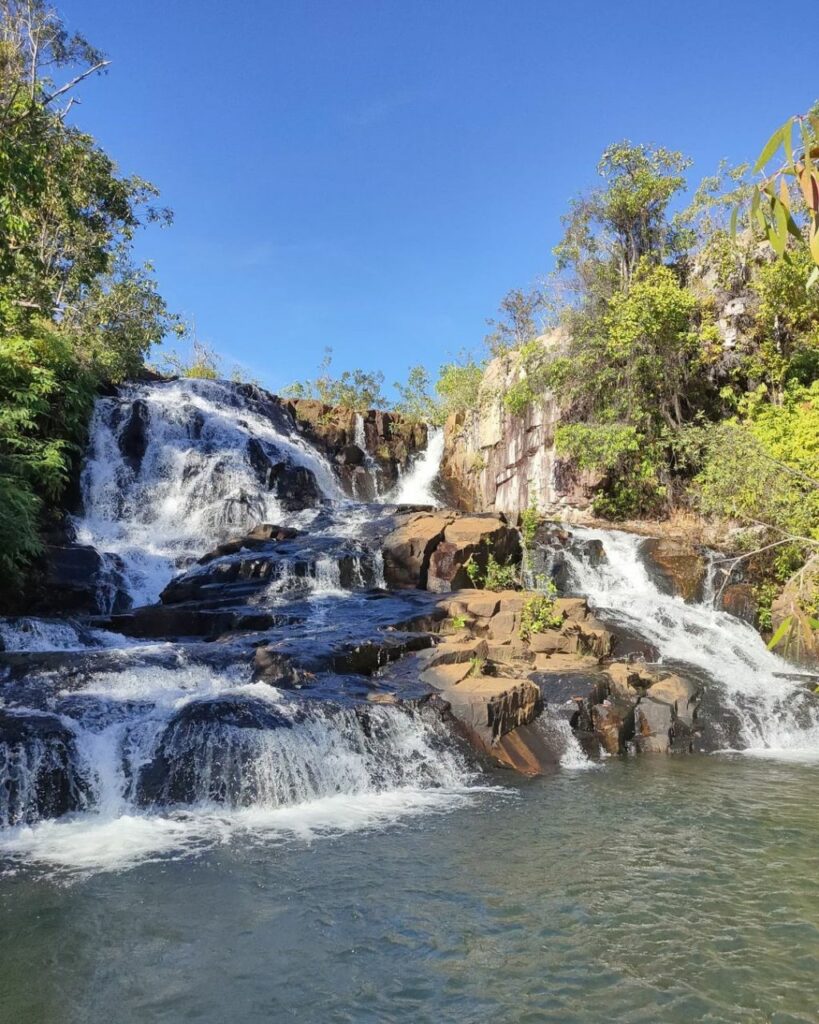
Cooling Off: There are several waterholes, creeks, and other swimming options that are safe to swim in, but on the Jatbula Trail, you should always be aware of your surroundings. Do not climb waterfalls or get close to cliff edges, and be on the lookout for fast flowing rapids and slippery rocks.
Top Jatbula Trail Tours
Jatbula Trail
📍Nitmiluk National Park, NT
⏰ 6 days
This challenging multi-day trek takes you deep into Nitmiluk National Park, following an ancient route across the Arnhem Sandstone Plateau. Designed for fit, experienced walkers, the journey covers 8–18km per day in warm tropical conditions, with early starts to beat the heat and relaxed afternoons for swimming and recovery at remote campsites.
With transfers from Darwin, boat shuttles to trailheads and hearty camp meals included, it’s a fully supported wilderness experience that rewards effort with raw landscapes, cultural depth and pristine waterways.
Jatbula Trail and Katherine River
📍Nitmiluk National Park, NT
⏰ 9 days
This immersive Top End adventure combines five days trekking the iconic Jatbula Trail with a multi-day kayak journey on the remote Katherine River.
Starting and ending in Darwin, the tour explores Jawoyn Country through Nitmiluk National Park, following an ancient Aboriginal message stick route past waterfalls, savanna landscapes and significant rock-art sites, before slowing down on the river with wildlife encounters, swag camping and true wilderness immersion.
We hope our comprehensive guide has helped in your Jatbula Trail hiking preparations! Enjoy your journey in one of the most famous multi-day hikes in the Northern Territory!
Have you explored Nitmiluk National Park or the Jatbula Trail? Share your experiences below!
Norther would like to invite you to explore more about the beauty of the Jatbula Trail and Nitmiluk National Park here. And… as always, you can get more inspiration for other National Parks & Destinations to visit by following @northerhq or get your Nitmiluk National Park daily fix @nitmiluknationalpark on Instagram or join the official Facebook group.
*Cover image by @grants_abroad